Cloud-Based Environmental Monitoring User Library
What are your needs for quantifying patterns of change in natural vegetation using Google Earth Engine?
This User Library can help direct you to the pathway most suitable for accessing aerial or satellite images for your environmental monitoring needs. For more information on our approach to broadening access to remote sensing data, see the published article:
Stahl, A.T., Fremier, A.K., Heinse, L., 2021. Cloud-Based Environmental Monitoring to Streamline Remote Sensing Analysis for Biologists. BioScience. doi.org/10.1093/biosci/biab100.
There are three main options to choose from, depending on your familiarly and comfort level with GIS and remote sensing.
Option 1: Not wishing to do your own coding, just looking for some maps?
Check out the gallery of example Apps at Earth Engine Apps
- The gallery offers several simple Earth Engine Apps demonstrated for Whitman and Garfield Counties, Washington State, USA that can easily be adjusted for other locations.
- viewAvailableNAIP and viewAvailableSentinel each enable the user to quickly search to see what imagery is available for a certain area in specified timeframes. This is one way that experienced GEE users can connect a broader user group with available data with no training required.
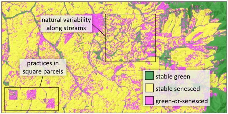
- viewCoverChange displays cover classifications that show changes in areas of natural vegetation within an agricultural landscape over a four year period. We used Sentinel-2 satellite data with 10-20-meter pixel size to generate these maps. The outputs are helping agricultural counties in Washington State meet their ecosystem monitoring and reporting needs.
Option 2: Interested in seeing the coding involved, but haven’t used Earth Engine yet?
Download this Tutorial. It walks you through the steps to generate the maps shown in the viewCoverChange App. Pair this with the documentation and files hosted on GitHub to learn how to code for yourself in the Earth Engine Code Editor. (First, you will need to sign up.)
Option 3: Ready to modify* and execute your own scripts?
Go directly to our GitHub repository and dig in!
*If you need to make your own riparian mask, try these instructions (courtesy of Grant Traynor, Walla Walla Conservation District, Washington State, USA)
Need to take data out of Earth Engine?
Try these step-by-step instructions for exporting maps from Earth Engine and analyzing them in ArcGIS Pro. (Courtesy of Grant Traynor, Walla Walla Conservation District, Washington State, USA)
Helpful Links
Vegetation indices: what is the difference between NDVI and NDRE?
- NDRE vs NDVI: What’s the difference? | by Aerobotics
- NDVI vs. NDRE: What’s the Difference? – Sentera